HOME    ATLANTIS   SPHINX UFO   RELIGION   PROPHECY   ONEISM   GRAIL   BIO   NEWS   CONTACT
   THE DISCOVERIES    THE STAR GATE   VIDEO    HUMAN CODE
 videos video video video video social media social media oneness donor  DONATE


STAR MAP STONEHENGE

Very few people have seen Stonehenge in its full ancient context as seen above. Mouse over the image to see the proposed Pleiades correlation. The area once surrounded in forrest would have had short grass clear of trees around the Winterbourne Stoke Barrows and Stonehenge itself. The cluster of barrows also has the typical leg of the bull shape found in many other ancient sites.

Stonehenge correlates with the known Sun star shown as Sol 1 Primary, the most important in the majority of the star maps while it has a unique long barrow correlate with the Sun star shown as Sol 3 Tertiary, which seems third most revered in the global collection of repeating cases of this ancient theme.

But would it not be absolutely complete if the ancients devised a geoglyph theme that explains humanity from this Sun star... if... its a star map of our ancestors as I propose?

I discovered something completely unexpected in 2014 studying a satellite image looking for lost geoglyphs. It is very common in earliest England where the first people there made beautiful chalk geoglyphs near their important settements... yet Stonehenge had nothing.


The ultimate geoglyph emerged as seen above... a narration having an ancient astronaut with Pleiades and with a strange rod like in the Egyptian Senmut tomb points the way to the Stonehenge 'x' that marks the spot. It seems to represent a sun star and in orbit... 4 planets in contention? Recently scholars believe there were 4 mounds although most prefer there were once only 2.

Mouse over the image to see tradition theme without the geoglyph.

Or is it the remains of a knight in shinning armour? I am more inclined to believe the geoglyph evolved from ancient astronaut to the obvious. No doubt by the Kings demands of a later era when the star visitor legends sounded more like crazy mythology and would be greater if it were the king depicted as a galliant knight.


A 'MAGICAL' 1 MILE LONG GEOGLYPH APPEARS

STONEHENGE 2014 - Mouse over the image to see the stunning geoglyph that emerged for a brief moment in time during a unique set of conditions experts are suggesting. The satellite image captured before the crop completely covered the soil at Stonehenge. Sourced from the satellite current (September 2014) default view image on Google Earth standard version (not pro version). Ref: Infoterra Ltd & Bluesky image Stonehenge frame date 14/8/2004.

Every very faint chalk line has been highlighted very painstakingly by hand. Image usage conditions:. Animation mouse over is available to any user site or media on condition the image source name is not tampered with in the bottom left frame area or the discovery of it, or image is simply credited as per name in bottom left frame.

I discovered this geoglyph September 15th 2014 while browsing google Earth looking at the positions the new radar image offered for underground anomalies. I was looking at the satellite image near Winterbourne stoke Barrows at the area where the radar detail showed structural lines and saw there were also faint lines on the satellite 2004 image.

I think Google Earth offer this 10 year old image as the current default image perhaps due to its fine sharp quality that is better than all the other images. Then I followed the lines towards Stonehenge where it seemed to look very strange.

I couldnt believe my eyes... it looked like an arm with glove and rod showing the way to Stonehenge! This seemed quite intentional in design and in great detail.


This is how the Google Earth image looks to viewers today as default view using Google Earth standard version. The faint lines only become clear as you zoom in as close as possible and plot each line 5m at a time.

After a whole day carefully highlighting the lines defined with the high chalk content I was amazed to see what you see here.

At first I thought this is more like an ancient astronaut depiction, but a knight with sword and shield and helmet now starts to make better sense. Its been ploughed over for centuries so expectedly it would look a little alien as it has distorted.

But what makes it special for me is the position between Winterbourne Stoke and Stonehenge, the main part of the star map theory that is part of this story and with a sword points to Stonehenge!

Here are the coords... see for yourself. It is very faint but every line reproduced is there.

Google Earth coords - 51°10'43.02"N 1°50'42.80"W

I have asked experts and they are now suggesting this is a real historical geoglyph as this area has history of many others during the Stonehenge era spread around the UK. They knew there were many strange lines here but most believed they were the remains of old settlement ruins beneath creating the lines. Perhaps the conditions were just right for this 'ghost' figure to appear. Maybe a ploughed field weeks old with little rain and lucky timing with the satellite image were the 'magic' factors. The chalk detail became noticeable for a short period and obviously more rain and crop growth makes it vanish again. Another theory to add is the plough was set much deeper than usual and this is what unearthed the chalk 'ghost'.

The only part permanently visible of the geoglyph is the top of 'the sword' as it reaches Stonehenge in an area that does not get ploughed. The full geoglyph does not appear completely on any other image overlays on Google Earth but one or two images still show slight details of portions of it. There is one new radar identified buried stone anomaly right in the middle of the geoglyph, the circle effect by the chin.

UPDATE An expert remaining anonymous looking at the specific satellite image agrees that this outline is caused by extra chalk residue and its no hoax and irrefutable proof something yet to be officially documented. He suggests it is very convincingly an ancient chalk outline of something where the chalk deposit is slightly raised above darker soil. A geoglyph figure that would have been cared after by its people during its time. The expert agrees it was possibly by chance exposed perhaps with a deeper than usual plough cut and photographed at the right time without crop coverage and the chalk dried out and brightened. This is no doubt going to be investigated by Heritage society experts.

There is more...

Look behind and above the head of the man in the geoglyph. It has the shape of a Grail chalice. Faint remains of stem and base but I am still trying to find more satellite images. The Grail fits with the knight, perhaps a Templar? This is the Grail area of star scape I decoded recently and yes it does fit the template of what we might be seeing. Here is the Grail secret that matches Stonehenge. ref


Ancient star map Stonehenge


Ancient star map Stonehenge


STONEHENGE - SUN-LIKE STAR CORRELATION

The Winterbourne Stoke Barrows mimic the Pleiades… and beyond all coincidence… Stonehenge is found in the precise position in which the pyramid replicating the mystery star in Egypt is found on a pyramid star map. Note also how Stonehenge has an outer circle with barrows that directy portray the obvious... a star with planets in orbit. Encrypted in the layout of Stonehenge is the stunning codex of the human form that I propose.

This is decoded from the age old Da Vinci Vitruvian man. The same codex can also be deciphered at Giza in Egypt and quite unexpectedly, also in a pyramid found at a place not of this world! The book reveals the ultimate solution to the pyramid enigma.

The star maps have been designed to convey a crucial message to humankind… a message that is also corroborated by a series of anomalies not of this world… the pyramids on Mars. 


STONEHENGE... THE 'X' THAT MARKS THE SPOT

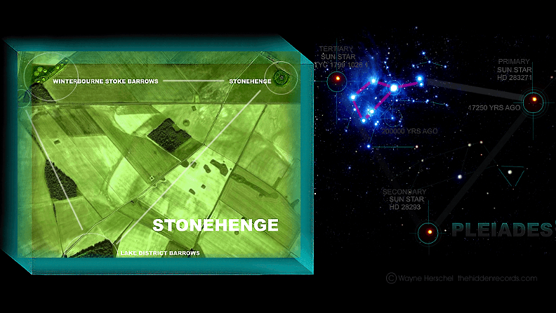
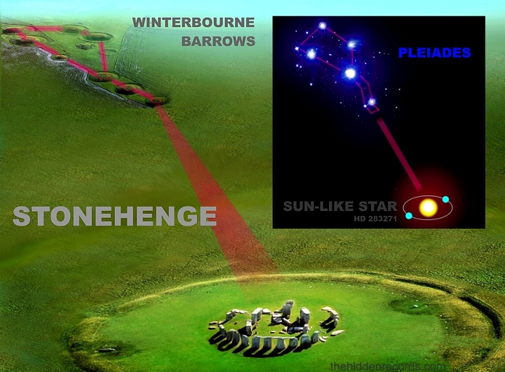
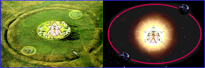
The Winterbourne Stoke barrows represent the Pleiades and Stonehenge marks on the ground the 'x' star that marks the spot. The meaning of Stonehenge appears to be the representation of the star very near the Pleiades stars... the star of the 'gods' of the ancients so to speak... flesh and blood visitors... also tied in to our ancestors who were mistakenly worshipped as 'gods'.

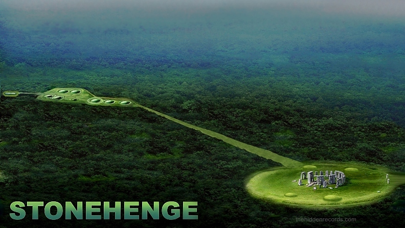
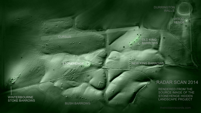
I have identified the meaning of the Cursus. (see images below). The Cursus represents the ecliptic, the path of our Sun... Why?

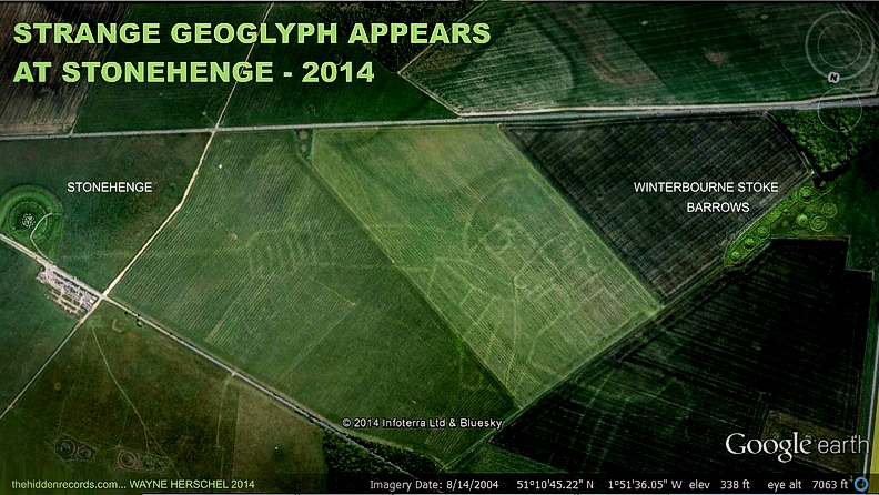
The reason is clear... Only a short portion of the ecliptic was celebrated. Both the Stonehenge causeway alignment and the Winterbourne Stoke wall alignments isolate a 'sacred' small portion of the ecliptic... they are most likely celebrating the rising of our Sun, with the Pleiades on one special day, then a few days apart, the ultimate celebration, the rising of the Sun-like star with our Sun viewed from Stonehenge!

The two alignments are without doubt a few degrees different to each other and here is where it makes most sense.

I am convinced the reason for this Sunrise with sacred star celebration is the ancients way of trying to emphasize THE MEANING of the star maps - to acknowledge the 'Sun' of our ancestors, which is LIKE our 'Sun'. A Sun-like star solution. Yes one cannot see both Sun and stars at the same time, but their once very advanced star watchers as well as our modern astronomers would easily decipher the meaning.

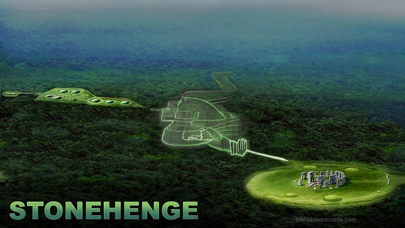
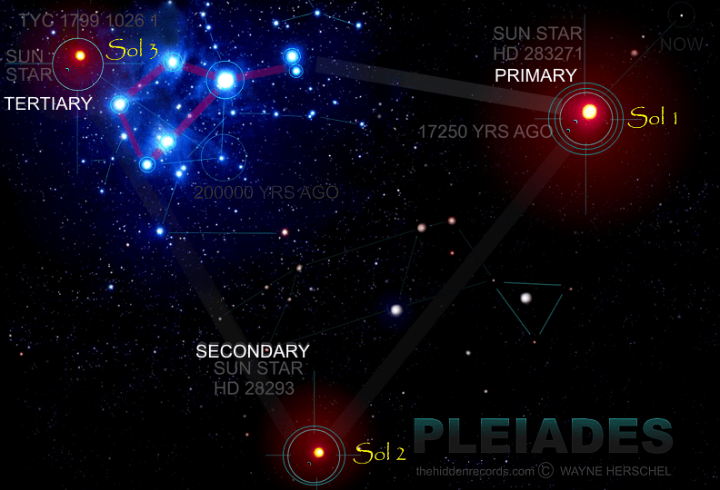
The oblong/rectangular-shaped barrow near Winterbourne Stoke has an important solution since publishing my book. It is in the exact position correlating with another important Sun-like star that is now important to include and compare to the Templars and Freemason secrets... THREE Sun-like stars as a grouping... A Trinity.

It mirrors an important Mars oval shaped anomaly. This 'extra' anomaly was excluded in my book because it complicated an already difficult story to follow, and it seemed too close for comfort to the Freemason star map which in 2002, (at the time of publishing, before the Da Vinci code book made its mark) seemed too risky to be writing about. The correlation match also closely resembles the Tikal historical site in Guatemala.

The third mystery anomaly here is in a historically protected piece of woodland in the lower portion of the image above, matching the position of the D&M pyramid in the Mars star map. I am appealing to anyone visiting the site (before my next trip) to take look there. There are a few mounds here but I have heard one of them that is completely overgrown with trees has an odd shape. See website contact link.

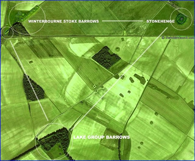
What interests me here are the boundary lines of the farms which seem parallel or set along what appear to be ancient alignment walls between the three important sites. See the white alignment lines and note also how the motorway is parallel to what apparently was once the ancient road that passed through the middle of both Winterbourne and Stonehenge.


2014 STONEHENGE RADAR SCAN

In the image above latest radar scans by the hard work of the Stonehenge Hidden Landscape project ref provided the first landscape image void of modern developments. Not only did it help identify all the old barrows lost on farm lands and under trees, it found anomalies beneath the surface as well.

More will be updated on what sensational claims called a Mega henge buried later when it releases. According to some scholars already, this is just a harmless hype to get media interested. Since the anomalies (the round dark dots on the image) are covered by a very shallow age layer not much more than 1 meter deep, it means what ever there is very low in height. This proposes either the less ancient rough stone circles that one finds common in the UK or perhaps the ruins of foundations left over from a circular building platform.

The area called Old Kings Barrows has 4 barrows in a row that align with Stonehenge. This was the first thing that screamed out it was Orion. But the name chosen for these barrows might not be by chance.

The old Templar name for the belt stars of Orion are the 3 Kings. The Freemason tradition followed with it there after and is explored on the Freemason star map page ref .

The string of barrows called New Kings Barrows look initially like the sword of Orion since the alignment might be correct although it should be on the other side of the Old Kings Barrows. My feeling here since the sword of Orion is made of at least six stas in a row it was probably either wanting a mirror reflection of Orion or more likely, wanting the tombs closer to the sacred area of Stonehenge, at a much later less knowledgeable period. A site where their kings over later generations could be buried in each barrow tomb within sight of Stonehenge.

But what can explain 4 stars iin a row for Orion's Belt? A special long exposure time image of the star area speaks volumes!


FOUR STARS OF ORION'S BELT


4 STARS OF ORION'S BELT ?

In the image above I propose this carefully exposed image showing nebula concentration close to the star Alnitak has the blast shape of a large near Earth supernova event perhaps somewhere around the 11000 years ago epoch. (Credit JF Althouse theory). This Supanova theory proposes Barnards loop nebula is the remains of a lost star that was once part of 4 stars in a row once for Orion's Belt.

This second blast wave of Barnards loop is visible to support this theory with an even larger picture of all the stars of Orion having its center based very generally around this area proposed where the 4th star of Orion's belt once existed as well. ref

This theory might sound a bit far fetched trying to explain away a pattern to make it fit but there is more. One of the oldest star maps in my work is the 17000 year old Lascaux cave painting in France, and this might explain why they added a fourth star there too. ref


FOUR STARS OF ORION'S BELT


It is important to mention a new interpretational development for what might correlate with the what is found common at other ancient sites for the second most important Sun-like star correlations.

A group referred to as the Lake district Barrows holds the solution to the position of Sol 2, completing the Solar Trinity tradition of some of the other star map findings. The reason for the trees not being cut down there is because of the large earth mound hiding in the trees.

Click here... Lake group barrow research by Julian Cope.

There are other sites that reproduce the sacred star pattern:

Click here... Egypt and Mars and the Maya on this menu listing here: New Star Maps

There is a lot more to Stonehenge and its design which I found also matches the secret of the Yule tree, the Egyptian Senmut tomb and more importantly...

... the stones positions replicating the design on the Hebrew Solomon Key talisman.

Click here...Key of Solomon parchment code, part two, half way down the page.

There is a human code message hidden in Stonehenge and it is shown below in just a few images, however completely revealed at this link here: HUMAN BLUEPRINT CODE

 
Stonehenge


THE HIDDEN RECORDS BOOKS


PLEASE JOIN OUR PATREON QUEST PLEASE JOIN WAYNE'S QUEST THROUGH PAYPAL


©The Hidden Records® 2024
Free Website Hit Counter
 
 
FULL SCREEN/NORMAL OPTION - PRESS F11
 
Credits - References - Copyright - General summary of ancient alien star maps proving star ancestor human origins explored in The Hidden Records book by Wayne Herschel. A Pleiades and Orion correlating pyramid star map interpretation was published in 1997 newspapers, followed by a Carte Blanche TV documentary in 2002 now on youtube. The Hidden Records book by Wayne Herschel released in 2003. (See book synopsis on website for more detail of The Hidden Records). There is a Pleiades correlation with Cydonia Mars, Stonehenge and Tikal and his new 2021 published Atlantis discovery show the same for Atlantis in Donana Spain. The site of an alien crop circle message with swastika and cross. The ancient alien human origin theory by Wayne Herschel claims humanity replaced Neanderthal. The ancient star maps of Orion and Pleiades correlation including three sunlike stars are all Wayne Herschel's copyright protected discoveries.